• Skip to primary navigation
  • Skip to main content

National Network for the Transportation Workforce

  • Home
  • About NNTW
    • About NNTW
    • Contact Us
  • 2025 Workforce Summit
    • Pre-Summit Webinars
  • News & Events
  • Mobility Matters
  • 2024 Tribal Summit
You are here: Home / Archives for News

News

TRB National Summit on The Future of the Transportation Workforce

The TRB National Summit on the Future of the Transportation Workforce will be held June 2-4, 2025 in Westminster, Colorado (near Denver). Be a part of the conversation as we address the challenges faced in each of the workforce life cycle steps and help identify the research needs of practitioners to ensure a resilient and skilled workforce for our changing modes and communities.

The Call for Abstracts invites presentations answering three key questions:

1. How do we attract and engage a diverse workforce?
2. What kind of workforce do we need for the 21st century?
3. What business models and tools sustainably support workforce needs?

Submit a proposal to present by *September 30, 2024.*
—————-

To learn more about the topic areas and to find out how you can submit your proposal, visit the call for abstract page here.


Filed Under: Featured, News

New NCHRP Report Features NNTW Researchers

The NCHRP report, Attracting, Retaining, and Developing the 2030 Transportation Workforce: Design, Construction, and Maintenance has been released. NNTW leaders Glenn McRae, Tyler Reeb, Tom O’Brien, and Susan Gallagher contributed. State departments of transportation are responsible for providing a safe, efficient, and effective transportation system of infrastructure and services. To meet these responsibilities, transportation agencies need a highly skilled workforce with the expertise required to identify and address current transportation needs while also being prepared to address the challenges of the future. This publication provides a guide with specific strategies and action plans to help agencies identify and address workforce needs through 2030 and beyond.

Filed Under: News

Mapping Technologies to Examine Transportation Workforce and Infrastructure Opportunities

Esri has created a digital storytelling tool known as a StoryMap. A StoryMap is a web-based application that allows users to create and build stories with customized maps. Users can contextualize their narrative in a StoryMap by embedding text, images, videos, and online content (e.g. web apps, social media posts, dashboards, and websites) to their map. The application provides templates for users to choose from and guides within the application, making the storytelling tool user-friendly. StoryMaps is part of the larger ArcGIS suite of web and desktop mapping and analysis tools. The app was designed with the integration of maps, data, and web applications created with those tools in mind. This allows embedded maps to be navigated and interacted with by users, enriching their experience.

StoryMaps are versatile in the ways they can be applied. CITT has incorporated StoryMaps into several of its projects and has found the tool to be helpful, in particular, as a training and presentation aid. Projects that have benefitted from the use of StoryMaps include: Workforce Training & Career Development, Supply Chain Infrastructure, and GIS in Transportation Planning. In Workforce Training & Career Development, CITT has applied StoryMaps as a curricular tool in order to demonstrate how data can connect to image and narrative to tell a story about a particular project. This is particularly valuable when communicating with diverse audiences. Teaching StoryMaps involves teaching GIS and how to communicate with it. Being web-based and integrated with other web-based GIS tools makes it more accessible and easier to distribute to students than desktop software. Participants in the 2020 Caltrans Freight Academy used StoryMaps to communicate the role of freight in their local regions, and CITT is developing a workshop for high schools that will use story maps to help students to explore, understand, and communicate sustainable transportation issues in their communities. In Supply Chain Infrastructure, CITT has used StoryMaps to share the results of research topics such as the impacts of COVID-19 on the supply chain. They are also useful as interactive maps to help visualize the supply chain throughout Southern California. For GIS in Transportation Planning, CITT has created StoryMaps that show how GIS is used as a tool in transportation planning and helps to reveal the unique characteristics of cities, communities, and individual blocks.

Thematic Forces

Workforce Training and Career Development

  • Southern California Regional Workforce Development Needs Assessment for the Transportation and Supply Chain Industry Sectors presents promising practice recommendations for program content, design, and delivery with developments concerning the role of Institutes of Higher Education (IHEs) in workforce education for supply chain industry sectors.

This image has an empty alt attribute; its file name is image-6-1024x544.png

  • Visualizing Sustainable Transportation Choices for K-12 provides a discussion on the benefits of introducing spatial thinking in K-12 education. GIS allows students to become spatial thinkers by collecting, analyzing, and visualizing their data. Visualizing their impact would help students participating in the GIS activity to strengthen their sustainable thinking.
  • Driving GIS Career Pathways provides a comprehensive summary of various steps necessary in choosing GIS as a career path. This demonstrates an individual’s journey from high school dual enrollment to obtaining an undergraduate degree and later joining the workforce.

This image has an empty alt attribute; its file name is image-7-1024x563.png

  • Top 25 Transportation Job Projections in the Southwest Transportation Workforce Center (SWTWC) Region highlights the top 25 job projections within each state in the SWTWC region and details critical occupations and related labor market data.

Supply Chain Infrastructure 

  • The Battle for the Curb: Managing Local Goods Movement in the Age of E-Commerce was used as an instructional tool in a pilot course for public and private professionals on the biggest goods movement challenges in the 21st century occurring in last-mile and last foot urban freight planning.

This image has an empty alt attribute; its file name is image-8-1024x564.png

  • Freight Corridor Planning and Improvement discusses designing and planning more efficient ways to reliably move freight in specific freeway segments with high truck volumes at a more granular level in California’s Inland Empire warehousing region, Ontario, California.
  • Maintaining and Improving Freight Corridors Using GIS provides a discussion on designing and planning more efficient ways to reliably move freight in specific freeway segments with high truck volumes at a more granular level in California’s Central Valley agricultural region, Sacramento, California.
  • Digital Freight Matching Technology and the Role of GIS demonstrate the potential benefits of DFM on the Trucking industry and the importance of GIS in alleviating inefficiency and congestion problems in society.

GIS in Transportation Planning

  • The Role of GIS in Protecting Cultural Resources explores collecting volunteered geographic information with tools like Survey 123 for transportation efforts to incorporate in the protection and preservation of cultural resources.
  • Assessing Los Angeles’ Complex Transportation Network emphasizes GIS and its importance in making well-informed decisions through the visualization of geospatial data, access of real-time transportation and survey data, and ability to perform comprehensive analyses on complex Los Angeles’s transportation datasets.
  • Addressing Passenger-Freight Conflicts in Metropolitan Communities Using GIS helps transportation and regional planners make better informed decision by collecting and visualizing areas of conflict in metropolitan communities with geodata.

This image has an empty alt attribute; its file name is image-9-1024x564.png

Suggested Categories:

1) Workforce Training & Career Development
2) Supply Chain Infrastructure

3) GIS in Transportation Planning

  • Top 25 Transportation Job Projections in the Southwest Transportation Workforce Center (SWTWC) Region
    • Visual resource displaying the top 25 transportation job projections in each of the eight states in the SWTWC region: Arizona, California, Colorado, Nevada, New Mexico, Oklahoma, Texas, and Utah
  • Addressing Passenger-Freight Conflicts in Metropolitan Communities Using GIS
    • Instructional tool for the 2017 METRANS Metropolitan Transportation Management Certificate Course
    • Winner of the 2017 Southern California Association of Governments (SCAG) Student Story Map Competition
  • Assessing Los Angeles’ Complex Transportation Network
    • Instructional tool for the 2018 GIS pilot course at Los Angeles Trade Technical College (LATTC) as part of the National Transportation Career Pathway Initiative (NTCPI)
  • Driving GIS Career Pathways
    • Hypothetical narrative of a high school student who enters a GIS career pathway
    • Finalist submission at the 2018 Southern California Association of Governments (SCAG) Student Story Map Competition
  • Maintaining and Improving Freight Corridors Using GIS
    • Instructional tool on the supply chain in California’s Central Valley agricultural region for the 2018 Caltrans Freight Academy in Sacramento, CA
  • Freight Corridor Planning and Improvement
    • Instructional tool on the supply chain in California’s Inland Empire warehousing region for the 2018 Caltrans Freight Academy in Ontario, CA
  • The Battle for the Curb: Managing Local Goods Movement in the Age of E-Commerce
    • Instructional tool for 2019 pilot course for public and private professionals on last-mile urban freight planning
  • Digital Freight Matching Technology and the Role of GIS
    • Visualization of digital freight matching as a solution to Southern California freight issues
    • Winner of the 2019 Southern California Association of Governments (SCAG) Student Story Map Competition
  • The Role of GIS in Protecting Cultural Resources
    • Discussion of the role of GIS in sustainable transportation planning at protected architectural sites
    • Finalist submission at the 2020 Southern California Association of Governments (SCAG) Student Story Map Competition
  • Visualizing Sustainable Transportation Choices for K-12
    • Instructional tool for K-12 audiences introducing GIS basics and sustainable transportation concepts
    • Second place winner at the 2020 Southern California Association of Governments (SCAG) Student Story Map Competition
  • Southern California Regional Workforce Development Needs Assessment for the Transportation and Supply Chain Industry Sectors
    • Comprehensive summary and visualization of the Southern California regional supply chain
    • Overview of the results of a 2020 needs assessment of the Los Angeles regional transportation and supply chain industry workforce issues

Filed Under: News

CITT Develops Strategies for Future of Highway Construction Workforce

Apprenticeship Program Best Practices Guide

In February 2020, the Center for International Trade and Transportation (CITT) developed the Highway Construction Apprenticeship Development Guide: Highway Construction Workforce Best Practices, a guide developed as a practical addendum to the Federal Highway Administration’s (FHWA) Roads to Your Future Playbook. This “Playbook” serves as a practical guide for employers on attracting, training, and retaining a skilled workforce in highway construction. It describes a series of recommended “plays” for employers to develop more resilient workforces that are based on findings from FHWA’s Highway Construction Workforce Partnership (HCWP) pilot programs. These pilots were created to help trained workers find jobs  or obtain promotion qualifications, build a  resilient  workforce, and develop  a new model for identifying, training, and placing individuals  on  the career path of a  highway construction  professional.

The Highway Construction Apprenticeship Development Guide—a companion piece to the Playbook—was developed by CITT’s Education and Workforce Development Analyst Deanna Matsumoto and Research Assistant Caitlin Mace, as part of a Southwest Transportation Workforce Center grant awarded to CITT by FHWA. As part of her work, Matsumoto and a team of research assistants conducted semi-structured telephone interviews with the Working Groups/Task Forces for ten out of the twelve HCWP pilot locations in order to gain insight on each Working Group’s best practices. The Guide matches pilot program recommendations with plays from the Playbook. A future update of the FHWA Playbook will incorporate CITT’s work to produce a final, comprehensive document.

There is a rising demand for highway workers, yet there is a deficit in the highway construction workforce. Industry surveys show that many highway contractors have trouble finding, training, and retaining qualified workers. CITT’s Matsumoto explains “The Associated General Contractors of America has stated that  60% of construction jobs go unfilled. To address this workforce gap, we identified several proven and innovative best practices that can be implemented with highway construction workforce development teams throughout the nation.”  Some of the recommendations in the Guide included establishing shared and standardized technology platforms, issuing certifications relevant to the field, educating career mentors on the benefits of highway construction jobs, and partnering with community and adult education organizations.

The Guide also develops additional recommendations for future career development programs, building upon those addressed in the Playbook. It recommends implementing many progressive strategies for outreach such as using social media to recruit workers, creating a “no wrong door” policy that seeks to fit potential workers into positions that best suit their skills, and targeting areas where mobility infrastructure development was a high need, thereby facilitating economic development for communities through mobility in addition to job creation. Other innovative recommendations included facilitating childcare services for employees, addressing transportation obstacles through ride-sharing and similar programs, and case management services to assist with external factors that play into career success such as housing, food insecurity, substance abuse, and financial literacy education. These recommendations were all pulled from best practices identified through the interviews with the FHWA Pilot Program managers.

The objective of this comprehensive Guide is to begin resolving the highway construction worker shortage crisis and building a resilient, sustainable, and technically savvy highway construction workforce. The recommendations laid out in the Guide help both employee and employer, support overall industry growth, and serve as an initial step in allowing the industry to address the growing demand for highway construction labor. The findings are also of value to a broader set of industry sectors, including those in transportation where apprenticeship programs are not well established but where workforce challenges demand a bigger toolkit.

Filed Under: News

Enter the Student Data Challenge

Iteris is proud to sponsor the Transportation Research Board (TRB) student data challenge on urban travel time, speed and reliability for the second year running.

Students are tasked with using the Virginia Department of Transportation’s Smarter Roads Platform or UMD’s COVID-19 Impact Analysis Platform to develop a study investigating the impact COVID-19 and stay-at-home orders have had on the transportation network.

Be sure to register by July 15, 2020 and submit your report by October 15, 2020, both at TTSRstudentdatachallenge@gmail.com.

The winner will receive a $500 prize, with top entries selected to present at a poster session at the 2021 TRB conference.


Filed Under: News

Jean-Paul Rodrigue Details COVID-19 Impact on Supply Chains

by Adylbek Abdykalikov, USC, IPPAM 2020

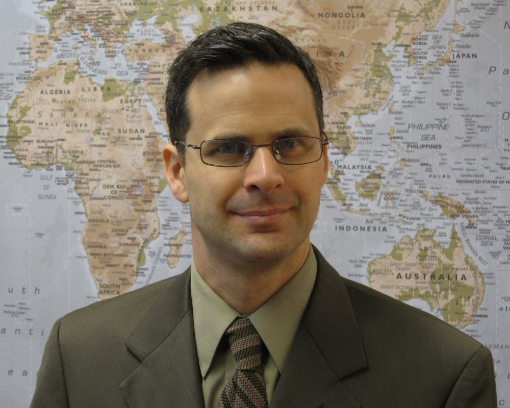
On April 3, 2020 Dr. Jean-Paul Rodrigue, Professor of Global Studies & Geography at Hofstra University, New York and a member of METRANS’ MetroFreight research center, presented his research on the impact of the COVID-19 pandemic on transportation to METRANS Advisory Board, faculty, and staff. Titled “Coronavirus Impacts on Trade and Supply Chains,” the presentation focused on the effects of the unfolding COVID-19 pandemic on international trade and supply chains.  Rodrigue was invited by METRANS Director, Professor and Ferraro Chair in Effective Local Government at the University of Southern California, Dr. Genevieve Giuliano.  “METRANS is fortunate to have a deep bench of experts from which we can draw,” Giuliano noted.  “Professor Rodrigue not only is one of the world’s experts in international trade, but also conducted a research project on the potential impact of a pandemic on global supply chains.  He is uniquely qualified to tell us what we can expect from this pandemic.”

Read the full article on METRANS.org.

Filed Under: News

  • Go to page 1
  • Go to page 2
  • Go to Next Page »

Copyright © 2025 National Network for the Transportation Workforce • Contact Us